Wildlife Walk 2 – Great Dunmow
Start Point – New Street Car Park. Map ref. 629/218
Distance 3.75 miles. Allow 4 hours. The walk leads out of Great Dunmow to follow the Flitch Way through Dunmow Cutting, with its wildflowers and butterflies, returning through agricultural land and past woodland.
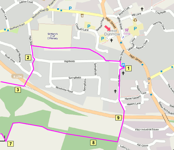 Great Dunmow Town Map (Start and Finish of the walk) © OpenStreetMap contributors, CC-BY-SA
1. Leave car park and turn right into New Street taking first left into Harmans Yard. Walking in front of the cottages, take the tarmac footpath on the right hand side of the road. Continue along the the footpath to the end.
2. Turn left to take the barriered pathway at the bend in road to the the side of the Highfield Road sign. Keep to the to the left hand path by the turning circle and continue down the steps to the Town Bypass. This is a busy road with vehicles travelling at high speed, great care must be taken in crossing.
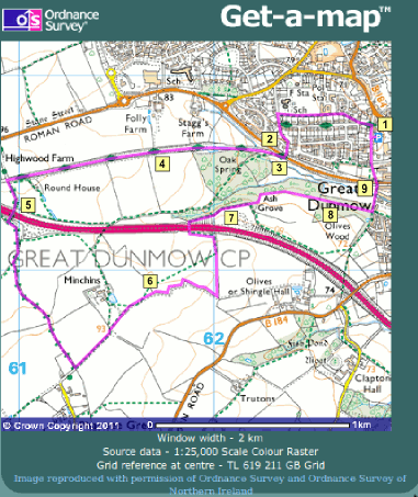 Great Dunmow Walk – rural section
Cross to the sign for Fitch Way “Cutting” Park. Follow the sign direction bearing right onto the main path, going over the bridge and continuing through the woods to join a “T” junction of paths at its corner. Turn right and follow the path until it joins the Fitch Way in front of a metal gate.
4. Turn left onto the boardwalk and follow the Fitch Way, enjoying the nature of this Wild Life Reserve. The boardwalk section takes advantage of the habitat created by the flooding of the former railway cutting, and this becomes a lush jungle of plants in the summer, where Damselflies and Dragonflies can be seen. The path leads onwards into a drier section of the cutting with a wide range of wildflowers on the north side, with its south facing slope which gets very hot on sunny days. A range of chalk loving plant species can be found, and many Butterflies; look out for Meadow Brown, Gatekeeper and Common Blue.
5. At the gateway at the end of the reserve turn left, proceeding across the bridge over the A120 to take the left hand fork leading to a track surfaced with road chippings. The surface applied to the track has made it easier to walk but has destroyed all signs of ground flora on the verges, an unfortunate loss of habitat, but keep an eye open for birds in the hedgerows. Continue to the end of this track and at the roadway turn left.
6. Following this roadway to the gate way to Minchin Farm. Take the stile to the right of the entrance and keeping close to the hedge arrive at another stile. Climb over this and continue in the same direction to join a track, follow this around the perimeter of the field. {NOTE ignore the green footpath mark across the centre of the field on the map extract, this path has been diverted around the field edges}. At the end of the hedge on the left of the track and at the point where a fence starts, turn left to follow another track towards the A120. Proceed through a gateway and down a slope to the tunnel to go under the A120, turning right at the end of this.
7.Continue along this track, passing the A120 Rest Area to enter a cultivated field.Take the track running around the edge of the field keeping the wood on the left hand side. This woodland edge is good habitat for birds, so keep an eye out. Where the track ends take the path to the right again keeping the wood on the left hand side, to complete the walk around three sides of the field. Staying on the same path turn left and proceed along the side the wood to the corner of the next field.
8. Turn left into the wood, turning right after a few yards onto a crossing path in front of a pond area. Such woodland ponds can be good wildlife resources, but do tend to get shaded and gradually fill up with fallen leaves. Walk towards the houses to join another path running in front of a fence. Turn left following this downhill. At the end of the fence continue on the tarmacked path, going over a small wooden bridge and up to the pedestrian bridge over the Town Bypass.
9. Walk over the bridge and continue along the tarmac path to pass the bollards at the bottom of New Street. Proceed up the slope of New Street to return to the car park on the right hand side after around 100 metres.