Cycle Ride 1 – Special Roadside Verges from Saffron Walden
About 18 miles with some hills, six special verges and 3 pubs. You should carry a good wildflower book, as well as the usual cycle repair kit, water and snacks.OS Map Sheet 154.
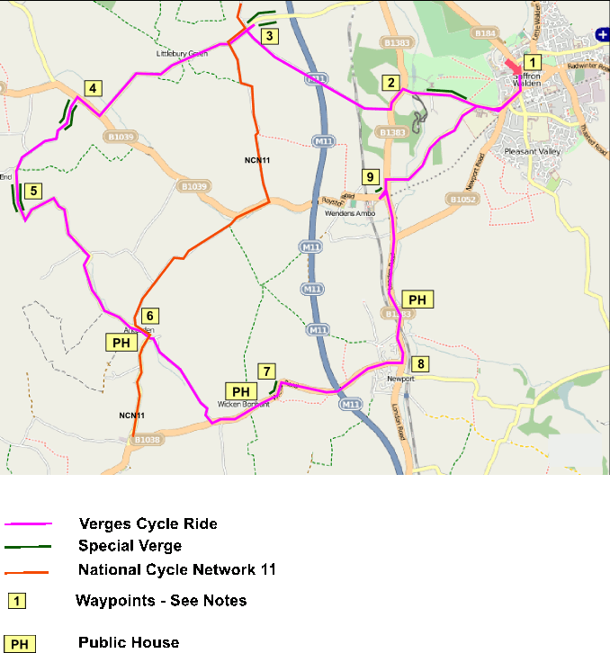
Cycle Ride 1 map© OpenStreetMap contributors, CC-BY-SA
START in Saffron Walden at the foot of High Street and ride south up the hill out of town on London Road, and then straight on through 2 mini-roundabouts along Audley End Road. Pass the County High School on your left and keep straight on at the T junction, following the wall of Audley End Park on your right hand side.
[1] One hundred metres past the junction look out for the Special Verge marker post on your right, designated as UTT46 Audley End Park Wall, and this verge continues all the way to the Lion Gate of Audley End House. The verge is scheduled for Lesser Calamint (find it around the first bench) and Pellitory-of-the-wall, with Wild Clary, and some other species. Invading Nettles are a constant management problem. Beyond Lion Gate you cross over the lake on a fine stone bridge, from where you can see waterfowl, and on summer evenings this is a good place to see bats.
[2] At the main road (B1383) turn left, this is a busy road and you may want to choose to ride on the narrow footway. Take the next right turn, signposted to Strethall and Littlebury Green. This is Chestnut Avenue, named for the Horse Chestnut trees that line it. A long gentle climb, passing under the railway and M11, up to the next crossroads, where you turn right, and go for a short distance to see a special verge.
[3] This is Littlebury Green Road, where the special verge, UTT39 Littlebury Green Road, starts at the foot of the slope on your left, and continues up the hill.
[NB IN June 2015 the County Council mowed this verge by mistake, and this has removed all of the wildflowers that should have been here. Some may regrow later in the season.]
Here you may find knapweed broomrape, greater knapweed, common knapweed, wild basil, marjoram, agrimony, field scabious, meadow vetchling, hedge bedstraw, rest harrow, perforate Saint Johns-wort, bird’s foot trefoil, yellow-wort, and maybe some others. When you reach the end marker, Retrace your route and look at the opposite verge on the way back which is also a marked special verge and has similar species.
Returning to the crossroads carry straight on into Littlebury Green. Keep following the same road, eventually making a fast descent to the junction with the B1039 Royston Road.
[4] Turn right and shortly come to a junction where you turn left onto the minor road to Duddenhoe End. Both sides of the road are special verges, known as UTT6 Elmdon Daws Grove, the one on the left, (East), possibly the best wildflower verge in Essex. These have cowslip early in spring, with a good range of chalk loving species, including meadow vetchling, marjoram, common knapweed, field scabious, hedge bedstraw, meadow buttercup, red clover and the rare sulphur clover. Continue up the steepening hill, then downhill and keep straight on at the next two junctions (i.e. do not turn right).
[5] Just past the second junction a shallow descent leads to the next special verge on both sides of the road. This is UTT5 Coopers End. The one on the left (East) has suffered from an encroaching hedge, and the one on the right (West)from fertiliser enrichment from the farmland, which has reduced the wildflowers here, but on the left past the field entrance you may find Crested Cow-wheat, formerly recorded across eastern Engand but now Nationally it has only been seen in 15 x 10 Kilometre squares since 1987 and qualifies for Red Data Book Status. In Essex, Uttlesford is its last stronghold with less than a dozen sites. this verge also has the chalk loving species; common knapweed, meadowsweet, meadow vetchling, tufted vetch, creeping buttercup, ribwort plantain, broad leaf plantain, red clover and
white clover. Follow the road which takes a sharp left turn at Coopers End, and begins a descent, and then curves to the right following Wicken Water, a seasonal river valley. Keep on ignoring right and left turns and continue on to Arkesden.
[6] Arkesden provides a useful resting stop at the Axe and Compasses pub. But then continue on, taking the left turn at the end of the village to follow the descending valley of Wicken Water all the way to the junction with the B1038 at Wicken Bonhunt.
[7] Turn left through Wicken Bonhunt, which provides a second pub/restaurant at the Coach and Horses. As you leave the village and reach a double bend there is a special verge on the left, UTT15 Wicken Bonhunt. Here you may find Sulphur clover,
yellow vetchling, cowslip, common spotted orchid, bee orchid, common knapweed, field scabious, Saint ohn’s-wort, bird’s foot trefoil, agrimony, wild carrot, hop trefoil, yellow melilot, meadow vetchling, common vetch, and hedge bedstraw. Keep on the same road into Newport.
[8] In Newport turn left at the T junction with the B1383 London Road and head north. Pass under the railway line and on your right is another pub, the Coach and Horses. This is a busy road and you may decide to cross the road and ride on the footway on the east side of the road. Continue on to the roundabout junction with the B1052, but keep on the B1383 where the footway crosses to the west side of the road.
[9] Ignore the minor road (left) just past the roundabout and keep on to the the next T junction, and turn left into Station Road, signposted to Audley End railway station. There is a special verge on the north side of the curved section of the road scheduled for Lesser Calamint. This is the final special verge of the tour. From here continue a short distance north along the B1383 and turn right onto Wenden Road, which descends and then rises, descends again and then up a steep hill back to the junction beside the County High School, and then back into Saffron Walden.
Hope you enjoyed it!